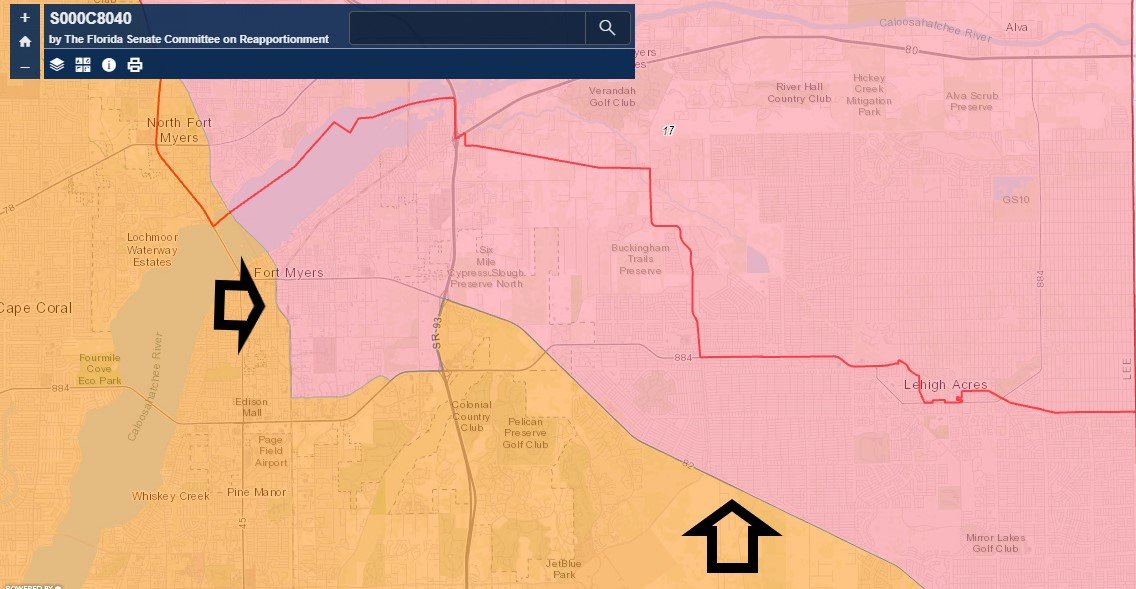
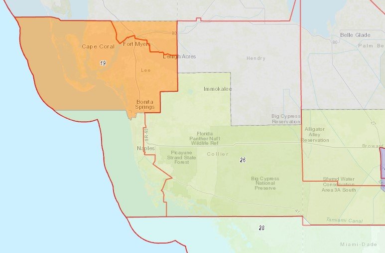
The transfer of north Fort Myers (left arrow) and Lehigh Acres (right arrow) into the 17th Congressional District in the map passed by the Florida Senate. The red lines denote the existing district lines. (Map: Florida Senate/Arrows: The Paradise Progressive.)
Jan. 21, 2022 by David Silverberg
By a vote of 31 to 4 the Florida Senate yesterday, Jan. 20, passed its version of Florida’s new congressional districts.
The new map makes only slight changes to Southwest Florida’s congressional districts but it does take a chunk of Fort Myers and Lehigh Acres out of the current 19th Congressional District and puts it in the 17th Congressional District to the north.
Those districts include considerable Black and Hispanic populations and dilute any potential Democratic voting blocks in the 19th, making both the 19th and 17th districts, already heavily Republican, even more so.
The Senate completely ignored a map submitted on behalf of Gov. Ron DeSantis (R), which made radical changes to Florida’s congressional districts. DeSantis has indicated that he may veto the Senate map, since he has to sign off on any congressional boundary changes.
The Florida House has yet to weigh in with a final version of its congressional map.
The Senate map
An overview of the Senate-passed congressional redistricting map. Red lines denote existing district boundaries. (Map: Florida Senate)
The map approved yesterday by the Senate (S000C8040) largely keeps existing boundaries and numbers.
This map was chosen and shepherded through the committee process by Sen. Ray Rodrigues (R-27-Lee County) who chaired the Senate’s Reapportionment Committee.
From the outset, Rodrigues said he was committed to avoiding the experience of the 2010 redistricting, which was challenged in court and took six years to litigate before final maps were approved.
The initial round of maps proposed by the Senate received a “B” grade from the Princeton Gerrymandering Project, an academic, non-partisan evaluation by Princeton University. It largely kept existing districts intact, while giving Florida its new 28th district. The B meant that the map was considered “better than average for the category, but bias still exists.”
As of this writing the new maps have not yet been graded by Princeton.
The Senate map keeps Fort Myers’ River District in the 19th and makes Park Ave. the boundary line between the 19th and the 17th in the west. State Road 82 becomes the boundary between the 17th and the 19th until it reaches Rt. 75 in the east.
It also puts the 19th District portion of Lehigh Acres solidly in the 17th.
The initial draft of this map was denounced by Democratic congressional candidate Cindy Banyai. “This is gerrymandering,” she stated in a Nov. 19 press release. “Most of the people who are no longer in FL19 are minorities, our Black and Latino neighbors. It’s well known that this district has always been a giveaway to the Republicans, but this clear targeting of our communities of color should alarm everyone.”
The DeSantis map
Gov. Ron DeSantis’ proposed map for Southwest Florida congressional districts. Red lines denote existing districts. (Map: Florida Senate)
The DeSantis proposal (P000C0079) largely follows county lines.
Under the DeSantis proposal, all of Lee County would constitute the 19th Congressional District. Collier County would constitute the bulk of a re-numbered 26th District, along with a chunk of Broward County as far east as Hialeah, the Cuban-American stronghold that provides the center of gravity for the current 25th District. A newly re-numbered 18th District would cover an immense swath of land including all of Charlotte County. Today, much of this area is contained in the 17th District.
An overview of Gov. DeSantis’ proposed congressional district map for Florida. Red lines denote existing boundaries. (Map: Florida Senate)
Analysis: Outcomes
It remains unclear whether the Senate or DeSantis maps will prevail when it comes to congressional districts. (The Senate also redrew state Senate districts. House districts will be redrawn by the state House. These do not need the governor’s signature to take effect.)
“We have submitted an alternative proposal, which we can support, that adheres to federal and state requirements, while working to increase district compactness, minimize county splits where feasible, and protect minority voting populations,” stated Christina Pushaw, the governor’s press secretary. “Because the governor must approve any congressional map passed by the Legislature, we wanted to provide our proposal as soon as possible and in a transparent manner.”
The controversies over the dueling maps will not center around Southwest Florida. The battles are emerging over heavily populated districts on the east coast in Democratic areas like Miami and Jacksonville. According to The Florida Phoenix, it appears “DeSantis’ proposed congressional map favors Republicans in 18 districts and Democrats in 10. Under the existing map, Republicans control 16 seats to the Democrats’ 11” whereas the “Senate draft contains 16 districts that went for Donald Trump two years ago and 12 likely to skew Democratic — a gain of one seat.”
Under the Senate map, existing representatives would remain largely in place, with Rep. Byron Donalds (R) representing the 19th, in which he does not reside, Rep. Mario Diaz-Balart (R) representing the 25th, and Rep. Greg Steube (R) representing the 17th.
Under DeSantis’ map, Donalds would have to choose whether to run in a 19th District that’s even further from his home—meaning a dual commute to Lee County as well as Washington, DC—or stay where he lives in the 25th and face off against fellow Republican Diaz-Balart.
If Donalds decided not to run in the DeSantis 19th, it could open the door to a new contender of any party.
For his part, if Diaz-Balart decided to run in the DeSantis 26th District, he would suddenly have a population center to contend with in a relatively urbanized western part of his district. Until now, the western part of the 25th was barely populated and Diaz-Balart could concentrate his attentions on Hialeah and his Cuban-American constituents with the occasional trip out to Immokalee serving as a show of some degree of concern for western constituents.
Though the redistricting process is far from over, the Senate map has the greatest likelihood of passage, although DeSantis’ wild card could still change the outcome of the game.
Maps must be finalized by June 17 when candidates qualify to run in the new districts. They’re more likely to be finalized by March 11, the last scheduled day of the legislative session.
Liberty lives in light
© 2022 by David Silverberg


